Still having the car we rented until we can get the annoying brake alarm in the truck fixed, we decided to drive some areas in the park where we can’t go with the truck. So we began by driving the Moose-Wilson Road. This road runs from near the Craig Thomas Discovery and Visitor Center past Teton Village to Wilson, a small town west of Jackson at the bottom of Teton Pass. The road gets narrow and curvy and has a load-limited bridge that our truck cannot cross. So the rental car gave us the perfect opportunity to drive this route. We didn’t see any wildlife along the way and it was a lot busier than we’d expected but we did pass a beaver dam that may warrant a future early evening visit.
 |
| Part of the National Elk Refuge |
Once at Wilson, we returned to Jackson where we decided
to eat lunch at Wendy’s. After lunch, we went back into the park and
drove to the Potholes Turnout. The area south of Signal Mountain is
dotted with geologic features locally called potholes but more
accurately called kettles. We walked a short, narrow loop trail around a
wooded area in the middle of the vast sage plain.
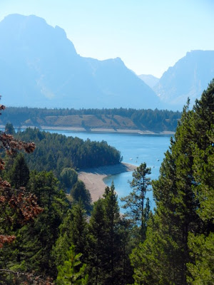
After the potholes turnout, we drove up Signal Mountain
to the overlook and the summit. Both locations offer magnificent
panoramic views of much of Jackson Hole from the Tetons to the Wind
Ridge Range.
 |
| Views from Signal Mountain |
 |
| Jackson Lake - notice all the sand bars that weren't there a couple months ago |
 |
| Leaving Signal Mountain - look at all the sand in this area where water was before |
We then returned to Teton Park Road and drove up to Signal
Mountain Lodge to stop for a snack. We decided to share a brownie sundae
but got a lot more than we bargained for! The sundae covered an oval
dinner plate and was mounded about five inches high with ice cream and
whipped cream. We managed to finish it with Lee eating the lion’s share
but Mary’s diet was certainly shot to pieces. It’s a good thing she had a
salad for lunch!
 |
| We shared a little snack - needless to say we didn't want dinner after this! |
 |
| He just had to eat the WHOLE THING! |
 |
| The dam - when we arrived water was almost to the top! |
From there we traveled to Oxbow Bend overlook and took a
few pictures but the sun was not in a very good position for pictures of
the mountain background.
 |
| Oxbow Bend |

After our “snack,” we drove up to Colter Bay to check out
the impact of the draw-down of water on the marina. It hadn’t been that
long since we’d taken a scenic cruise out of this very marina but now
all the floating piers are sitting on dry ground. There is no water in
the marina whatsoever. It’s been dry for so long now that it doesn’t
even stink any more. The pictures show the result but don’t tell the
whole story. The top thirty feet of water in Jackson Lake is controlled
by a water resources project in Idaho responsible for construction of
the dam. The dam project was built prior to any development controls and
the incorporation of Jackson lake in Grand Teton National Park. This
year, they decided they needed that top 30 feet of water for irrigation
and announced in July they were going to draw the lake down 30 feet to
the pre-dam level. They are entirely within their rights to do this and
have several times in their history. The result though is that no water
gets into the Colter Bay marina so it is left high and dry, a
disappointing situation for those who dock their boats there and may
have waited years for an available slip.
 |
| Colter Bay |
 |
| Boat Dock at Colter Bay |
So it was on to Leek’s marina, located further
up the shore on Jackson Lake from Colter Bay but at a deeper location.
Colter Bay is a sheltered, shallow cove but Leek’s Marina is right on
the shore of the lake. So the marina was still functioning just at a
much lower water level. The lake looks like it has a beach all the way
around it where the water has receded. If you compare pictures here with
those in the Trip Journal back in late May (when returning from
Yellowstone) you can see the difference in the water level on the boat
launch ramp. In May, there wasn’t much more than ten or twelve feet of
the boat ramp from the parking lot to the water. Now there’s probably
more than a hundred feet of ramp.
Following our visit to Leek’s we drove back to Gros Ventre campground via Antelope Flats where we looked for animals. The last time we were here we saw a couple of wolves. This time we found a flock of Greater Sage Grouse.
.
 |
| Can you find the bird in this picture? |
She is right in the middle of the picture behind the green sage. You can tell that God has dressed her in Camouflage! She is a Greater Sage-Grouse. It's the first time we have seen one to get its picture. No wonder! The male is more showy but we didn't see any of them.
 |
| Here on the pavement you can see her better! |
 |
| There were a number of females in the area. |


